

The Energy Data Conduit
We provide comprehensive data management solutions for all your commercial vendor subscription and company proprietary data. Your entire company, from field to executives, will use the same evergreen data with no per-seat or per-use charge. The Conduit delivers an analytics and spatially enabled SQL Server database with pre-built templates. We deliver out-of-the-box and configurable integrations for geoscience, geophysics, and engineering applications.
Built for speed, built for analytics, built for mapping
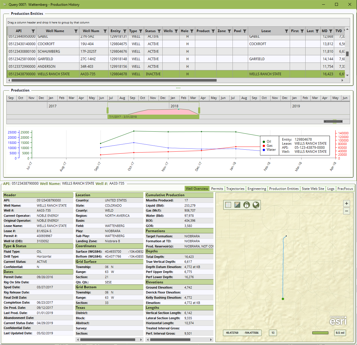
Our Well Finder application offers fast and simple access to Well, Completion, and Production data. We are strategic partners with Tibco and ESRI which allows us to provide full support for Spotfire, ArcMap, ArcGIS Pro, and Portal.
Unique to the industry is our ground-breaking Well Log Registry application suite. This solution searches the network to find and catalog logs that your company has acquired over the years. This is the fastest way to find the proprietary and local logs you need. Now you can find specific curves, such as gamma rays, available in any area of interest.
We have an Energy Data Conduit available for immediate deployment for the leading energy data providers
Comprehensive Access To Data In A Locally Managed SQL Server Database
Automated Updates For A True Evergreen Solution
Analytics And Mapping Enabled Out-Of-The-Box
Conduit Control Monitoring To Maximize Uptime And Reliability
Oil & Gas Specific Integrations For Accounting, Engineering, And Geoscience Applications

built on an Enterprise Platform
We build our products using Microsoft technologies including Active Directory, Azure, .NET, and SQL Server. Our solutions are meant to be plug and play with your environment and are easily supported by IT departments.
We will take care of all installations, maintenance, upgrades, break fixes, and more. This is at no extra cost, covered by our normal subscription agreement.
All solutions self-recover if the vendor is offline or if your system is offline for any reason.
Our cloud-based Mission Control suite monitors all systems ensuring optimal performance. These systems and our support team earn us our reputation for excellence.
We support clients in every type of environment, including:
Amazon AWS
Hosted
Hybrid / Colocation
Microsoft Azure
On Premise
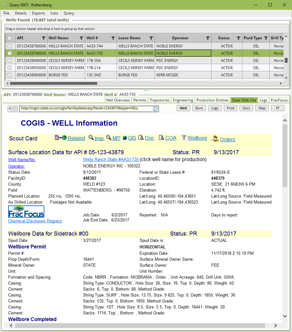
Well Finder Application with State Module
The Well Finder application allows for quick and simple data access and is purpose-built for IHS Markit and Drillinginfo.
The ability to query, view, and export data to common formats.
Spatial queries and result sets available.
Oil and gas specific tools, such as the ability to load an API list to query for recent activity and updates.
Common data types include: Wells, Permits, Geology, Perforations, Tests, Treatments, Directional Surveys, Completions, and Production.
No login required, available to every user on a domain.
The State Module - direct Regulatory website access
Well Finder contains the state website module; granting direct access to oil and gas regulatory websites.
Loads websites with a selected well from Well Finder, providing access to state data.
Access available for 20+ predominant oil and gas producing states.
Direct access to the state maintained web mapping portal.
PRE-BUILT & Pre-Loaded Integrations
Energy Systems
Configurable integrations deployed in only a few hours. Data is formatted for your specific needs and applications.
Common integrations include:
ARIES - Direct database load including ACProperty, AC_Completion, and AC_Product tables. Complete project overwrite, blended with your propnums, individual columns blending, data loaded how you need it.
Petra - Automated 297/298 downloads filtered for each project area on any schedule. Custom data, including our production aggregations exported and loaded into zone items when desired.
Harmony - Custom database well header and production history views for each project area. Scheduled and automated SQL Server to Harmony data loads at night or over the weekend. Your Choice.
GeoGraphix - Automated 297/298 downloads for each project area. Automatically loaded into each project with one scheduled task to download, move, and import the data into wellbase.
Petrel - Custom CSV exports from the database specifically built for your project area and data needs. All files are generated on any time frame and available for project import.
And More…
Analytics Ready
Spotfire
Tableau
Power BI
Excel
More


Spatially Enabled For Mapping
SQL Server Spatial
ArcGIS Server
ArcMap
ArcGIS Pro
ArcSDE
QGIS / Geoserver
Don't see the application or integration you are looking for? Please Contact us, we would love to add your specific application to our list.